 One of my favorite things to do is to explore different hiking trails. It's probably the only time that I can say I am truly happy and excited. Taking photographs of what I see around me is just a natural extension of that happiness, to share in what I find. If you go on any of these trails yourself you may find different things that interest you or see something interesting that I missed (which is most likely). It's all part of the experience of being out there.
 The Seaton Trail is a 13 km hike from 3rd Concession near Brock
 Road in Pickering and continues northwest to highway 7 at Green River. There are 3 different entry points to the trial from Pickering to Markham as well so be sure to map it out well before heading out.
 Although my hike started from the south to the north, I will outline the hike from the north to the south for you which is way more straight-forward. It is as follows:
Green River: Entrance is located on the south side of Hwy 7 at Green River (200m east of West Duffins Creek bridge)
Whitevale: From the parking at Whitevale Community Park, there is an access to to the trail which travels south on the west side of the river.
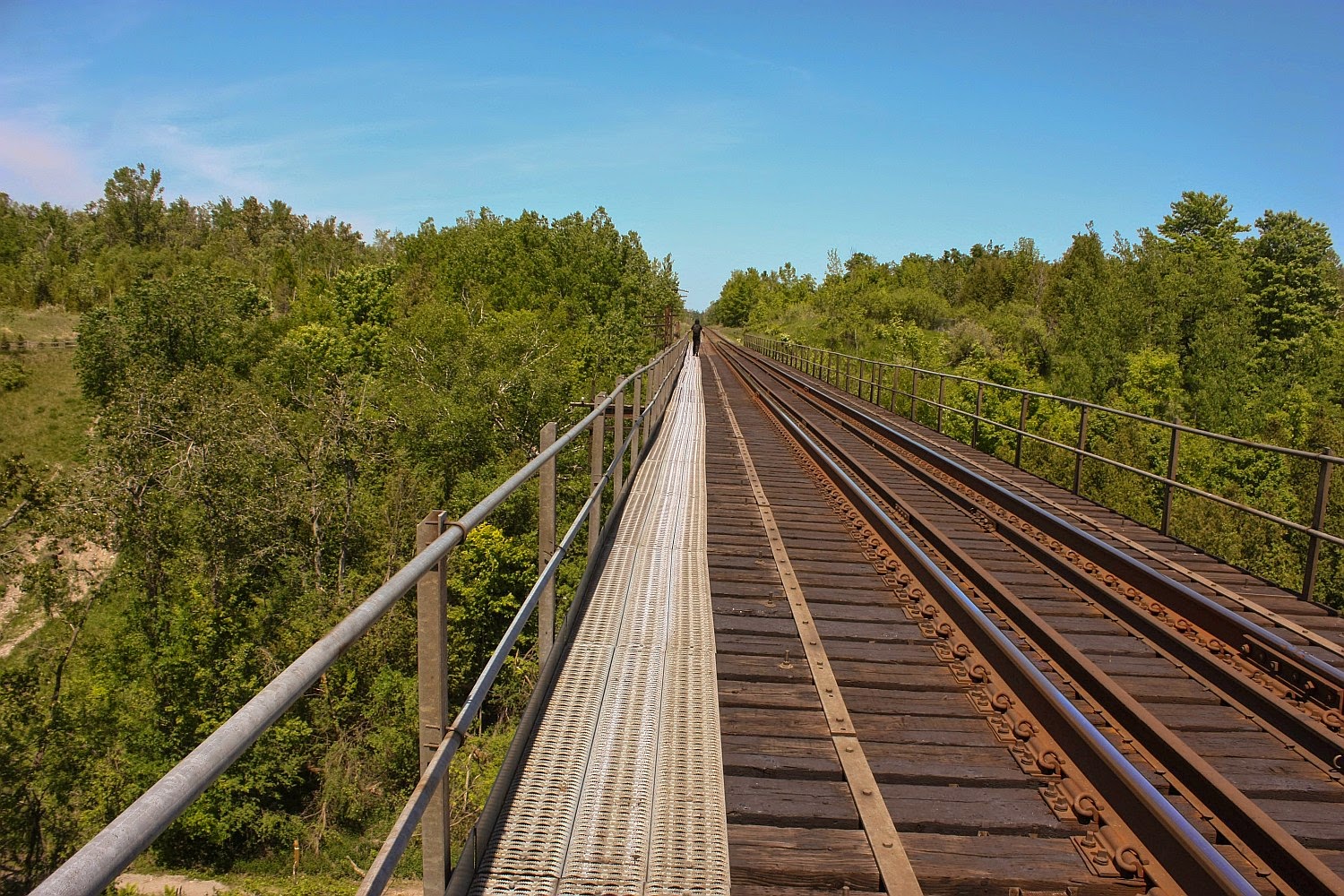
| Train bridge |
Forestream: 500m south of Taunton Rd, turn east onto Forestream trail off of Whites Rd
Grand Valley: Continue west on 3rd Concession from Brock for 1 km
The trail itself is a historic one and used for centuries by aboriginal people as a hunting and fishing route on the creek.

 The
Seaton Trail Hike is a great endeavour so you are looking at least 4 to 5 hours
to finish it all. The hike on this day started out as a decent on a small hill
off Valley Farm Road onto a short trail known as 'River Trail'. There is
no point starting from here, as it runs out, so if you want to follow the
markers you'll want to go a few 'clicks' north on Valley Farm to Concession 3
and head west where the official trail starts. Unfortunately we didn't go
north, but rather decided to sneak in early at 'River Trail' which ran out
bringing us to the back of a school and into a field full of power pylons.
The
Seaton Trail Hike is a great endeavour so you are looking at least 4 to 5 hours
to finish it all. The hike on this day started out as a decent on a small hill
off Valley Farm Road onto a short trail known as 'River Trail'. There is
no point starting from here, as it runs out, so if you want to follow the
markers you'll want to go a few 'clicks' north on Valley Farm to Concession 3
and head west where the official trail starts. Unfortunately we didn't go
north, but rather decided to sneak in early at 'River Trail' which ran out
bringing us to the back of a school and into a field full of power pylons.
 At
some point we ended up on a rail bridge, and it's a long one. So we
crossed it, heading north. There were points on the walk across while
looking down that I wondered if the railing was broken or the metal braces
underneath would hold me, but I knew at that moment that I was still willing to
continue and take pictures. Although I can't say I took any award winning
shots, as I disliked the brown water that often flows at this time of year
because the mud is washed out, I can honestly say that I had a few moments
of terror.
At
some point we ended up on a rail bridge, and it's a long one. So we
crossed it, heading north. There were points on the walk across while
looking down that I wondered if the railing was broken or the metal braces
underneath would hold me, but I knew at that moment that I was still willing to
continue and take pictures. Although I can't say I took any award winning
shots, as I disliked the brown water that often flows at this time of year
because the mud is washed out, I can honestly say that I had a few moments
of terror. Once off the bridge it was apparent we'd lost the trail briefly but there was no way I was going back on the bridge. Sometimes though, going off the mainstream can lead you into new finds that you otherwise wouldn't see, such as the huge field that was set in a valley. There were orange markers around it, and a strange collection of large rocks in the centre. It looked as though it was levelled out like something in a Sci-Fi flick.

 Still do not know what this land was used for but "Seaton Trail' got its
name from the planned community of Seaton which was envisioned in the 1970's to
accompany a new airport that was planned for the community. In the area,
you will see signs up from the locals indicating 'SAY NO TO AIRPORT'. It's possible that they
orange markers are in place for the location of the Pickering Airport now being
debated and discussed.
Still do not know what this land was used for but "Seaton Trail' got its
name from the planned community of Seaton which was envisioned in the 1970's to
accompany a new airport that was planned for the community. In the area,
you will see signs up from the locals indicating 'SAY NO TO AIRPORT'. It's possible that they
orange markers are in place for the location of the Pickering Airport now being
debated and discussed.
Back on track, literally we find
where the trail picks up again. Into some more beautiful tree laced paths
and emerald grass. The odd boulder placement here and there, left over
from the Ice Age, adds a nice scenic touch for pictures.

 As time passes the creek continues to evolve and cut a path through the earth.
What I loved about the Seaton Trail were the extraordinary landscapes, from
thirty-metre-tall eroded cliffs to a majestic cedar forest and a beautiful
stand of hardwood.
As time passes the creek continues to evolve and cut a path through the earth.
What I loved about the Seaton Trail were the extraordinary landscapes, from
thirty-metre-tall eroded cliffs to a majestic cedar forest and a beautiful
stand of hardwood.
 The
river is full of salmon, rainbow trout and brook trout which make the creek
their home at various times of the year. The fresh, cold water originates
from the Oak Ridges moraine to the north and is a perfect environment for fish
to spawn.
The
river is full of salmon, rainbow trout and brook trout which make the creek
their home at various times of the year. The fresh, cold water originates
from the Oak Ridges moraine to the north and is a perfect environment for fish
to spawn.I saw my first trillium flower, which is the Ontario flower symbolically, but I had never seen one on a trail. It's illegal to pick them too, I hear. We saw an unusual plant that we have yet to identify with a very large radial leaf pattern.

 The
trees had a story to tell as well, including one trunk which looked like he was
lending a helping hand, and another one had a bit of entertainment value.
The
trees had a story to tell as well, including one trunk which looked like he was
lending a helping hand, and another one had a bit of entertainment value.
One
of the trees we saw were cut open at the base and showed obvious signs of
infestation. My husband said it was called, 'emerald ash borer'. I
did some reading and found that the emerald ash borer is a green beetle native
to Asia and Eastern Russia. Outside its native region, the emerald ash borer is
an invasive species, and emerald ash borer infestation is highly destructive to
ash trees.
 However
by far, my favourite part of the forest was the walk through the ferns.
Ferns first appear in fossil records over 360 million years ago and now there
are over 19,000 species of them. Victorians loved the famous plant,
calling their craze of fern collecting and fern motifs in art as "Pteridomania"'.
Ferns were found in their pottery, glassware, printed paper and silverware.
However
by far, my favourite part of the forest was the walk through the ferns.
Ferns first appear in fossil records over 360 million years ago and now there
are over 19,000 species of them. Victorians loved the famous plant,
calling their craze of fern collecting and fern motifs in art as "Pteridomania"'.
Ferns were found in their pottery, glassware, printed paper and silverware. Finally
after six hours of trekking (taking pictures and rerouting time) we saw the
clearing for the trail finish. I must admit we were shy of the finish line by 1
km. This was frustrating as we set out to the do the whole thing, and
I've attached the trail blaze we did if you ever want to follow our route; make
sure you have a car waiting.
Finally
after six hours of trekking (taking pictures and rerouting time) we saw the
clearing for the trail finish. I must admit we were shy of the finish line by 1
km. This was frustrating as we set out to the do the whole thing, and
I've attached the trail blaze we did if you ever want to follow our route; make
sure you have a car waiting. 

 We
ended up walking from Whitevale Road to Markham Road which added another hour
and a half, not to mention the horrible Markham transit, which allocates buses
every hour and doesn't have designated bus stops at main intersections either;
even with over an hour wait times the drivers won't even slow down if you
aren't at a stop. We didn't get on a bus until 10:00 at night. It
didn't make sense to bring a car as we'd have to stumble back to get it anyways.
This wasn't the most convenient trail, but it was well worth the venture
in. My suggestion is to do it in sections or be well prepared to make a
day of it!
We
ended up walking from Whitevale Road to Markham Road which added another hour
and a half, not to mention the horrible Markham transit, which allocates buses
every hour and doesn't have designated bus stops at main intersections either;
even with over an hour wait times the drivers won't even slow down if you
aren't at a stop. We didn't get on a bus until 10:00 at night. It
didn't make sense to bring a car as we'd have to stumble back to get it anyways.
This wasn't the most convenient trail, but it was well worth the venture
in. My suggestion is to do it in sections or be well prepared to make a
day of it!
Happy Trails!


