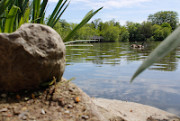
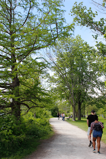
Showing posts with label Exploring Parks and Trails. Show all posts

Sep 30, 2019

Silver Creek Conservation Area (Scotsdale Farm)


Within the Silvercreek Conversation Area near the lovely and quaint town of Georgetown is a hidden treasure called Scotsdale Farm. It's a working farm, but there is so much more to this place.  For one thing, there is over 530 acres of gorgeous trails in and around the Niagara Escarpment.  

One of the most popular and largest trail here is the Bennett-heritage Trail.  Fall is the best time of the year.  For the simple abundance of colour, the crisp and cool air and the many photo opportunities you can capture if you are so inclined. 
             
We met up with a fellow photographer who had won a Canon contest while shooting here.  The sunsets here just rock through the trees.  Perfect setting - perfect lighting.  In fact this is a fave spot for many photographers and film producers.  Parking is free and ample as long as you are out of there by 8 p.m. at night when the park closes.
There are a few waterfall features here as well! 

Not in comparison to our friends out west in Hamilton or Niagara, but enough to keep your interest up.  Since it's part of the Bruce Trail network, you are bound to find plenty of rolling hills and woodlands and glacial rocky remnants to exercise your legs making it a great work out.

Halton Hills region has been a favourite for a few years now with so many conservation areas and things to do here all year long - set in a pastoral countryside.  

The main house of Scotsdale was built in 1836 by Christopher Cook. The farm was bequeathed to the Ontario Heritage Trust by Stewart and Violet Bennett in 1982.  Bennett had developed Scotsdale into an internationally renowned breeding farm for his Arabian horses and shorthorn beef cattle.

To learn more about the Bennetts and to the historical beginnings of this beautiful landscape which has  has been, click on the link below


Jun 9, 2019

Markham's Rouge Valley Trail -Wilbur Latimer Way

 We went on a nice walk with family this afternoon in Markham.  Met up initially to do some pottery painting, but it was far too busy in the 'Crock Pottery Barn' so we all strolled along the Main Street in Markham which is always bustling with locals and tourists especially when the weather gets warmer.  


One of my favourite shops is the old Firehall which has been turned into a confectionery shop with every kind of sweetness your heart desires.   There are plenty of outdoor cafes, patio bars, ice cream shops and crafts boutiques. 

My son and his fiance have a young Pomeranian puppy which came along for the walk too!  They call  it 'practice' for when the real baby comes, but I know there's a lot more to it than that! But I don't want to scare them off on the idea :)

Just a little piece of history about the Town of Markham:  It was founded in 1791 when John Graves Simcoe was appointed the first Lieutenant-Governor of Upper Canada.

Simcoe spent much of his term making improvements to the military security of the new territory by clearing Yonge street, and creating a system of free land grants, both of which greatly influenced the establishment and growth of what became the Township of Markham. He also responsible for giving the Township its name, after his friend, William Markham, the Archbishop of York at the time.

The architecture in Markham is seen today as some buildings still stand that were built as early at the late 1700's in the Georgian style tradition with simple details and an unadorned look of symmetry and practicality.  

The Georgian Tradition was tweaked in the mid 1800's into nuances of other forms of architecture like Regency, Ontario Cottage and Classic Revival which added French doors walking out onto tent-like verandas and bell-cast roofs with trellised and garnished posts - while keeping the symmetry as in the arrangement of the Georgian style.

I just want to add a little more about historical architecture...  Of course the reaction to this restrained and rational Georgian style became tweaked once again by the late 1800's during the "romantic era"  as seen in the style of Gothic, Roman, French Victorian and Italian with elaborate designs of steep roofs, bay windows, dormers, turrets, multi-paned and stained glass windows, fancy verandas with turned wooden posts, patterned shingles and decorative brackets and spandrels (spandrels are the decorated triangular pieces on either side of an arch)

However, most of the bubble popped by the 1900's to mid-century from the elaborate and garish design right back to its humble beginnings with simple box-like 2 storey structures.  Although there were no exterior ornaments, inside had chunky railings and decorative glass windows.  It was practicality at its best.  If you take heritage walks in Markham you can see examples of all of these style of homes and buildings.  That will be something I will want to do this summer.

The Markham today is one of the most diverse and financially successful towns in Canada and still growing.  It has beautiful parks as it's geographically located in parts of the Rouge Valley system. 


One such parkland is the Wilbur Latimer Way trail, which is part of Markham's Rouge Valley system.  As you can see by the photographs I took, it has so many features that any good trail would have.  Water fountains, water falls (small ones), bridges, vast green open spaces for picnics, and lots of trees and of course a lake bed with plenty of waterfowl.  

Oh and who was Wilbur Latimer?  This one was much harder to locate.  I still really don't know who Wilbur Latimer was, but I can tell you that his family owned several properties in Markham dating back over a century ago.  He was born in 1898 and passed away in 1993 and was laid to rest with his wife in the Bethesda Lutheran Cemetery in Markham. 

Markham's in full seasonal swing now if you come over and bring a basket or two.  Fill up on fresh cut flowers, locally grown produce or stock up on some goodies.  You can see on any street in Markham the old with the new world feel.  Quaint and rich in heritage, it's really a fun place to live and visit.

Jun 8, 2019

David J. Culham Trail - Mississauga


What a fantastic weekend, and so long in coming!  It seemed like winter would never end!! I almost didn't put away our winter clothes into storage because I was so sure that the ice would come, snow fall again, and the icebox would remain open.  But, alas with spring well behind us and summer simmering into the shadows I really think we can do just that.  Stow away our long coats, rainy boots, snowy boots and woolen mittens.

Without further ado, my summertime blog is underway with more treks and trails to explore.  Super-stoked and looking forward to it this year.

We headed for the David Culham Trail on Saturday with the plan that we would do a couple of kilometres after our lunch.  It turned out to be over 12 kilometres and it really didn't feel much like it at all.  We actually picked up the David Culham Trail after scouting through a few parts a little north east of it first (Credit River and River Run).  It's a very secluded neighbourhood with no throughway traffic permitted and I think they like that way and I don't blame them, so finding the entry point where we did was sheer luck and nothing else as it's not publicized.

The David Culham trail breaks up into two sections.  Dundas Street to Mississauga Road (which is Streetsville) and Church Street to the U of T Campus in Mississauga (Erindale park).

The Trail runs along the Credit River for most of the way but does share both urban and nature settings.  This is part of how the land is used and mostly due to urban development as the city grows so there's no way around having to share the peace of the forest with the noise of the city,  especially if you think you can ever get any peace when you're just minutes away.  If you are looking for that type of seclusion, you'll have to drive quite a lot further away from this trail I'm afraid.

Like other namesakes, I'm interested in the historical aspect of how trails are named or better yet who the person was behind the namesake.  This was an easy one and thanks to Google, it never takes long before we can find answers to any questions we have.

Don't you think that that has become a bit of a curse and a blessing?  I remember we as kids had to go to the local library to look up famous people, or explore historical facts like this.  Going to the library required effort, and gave us a purpose of some kind.  We met people, asked for help, shared ideas, listened and learned from others.  Now it's at your fingertips.  I'm not saying anything no one else has ever thought about, I'm sure.  My sons both have a keen interest in knowledge finding answers to everything.  That I respect in them.


Back to my story here about namesakes.  Who was David Culham?  He was a one time sitting Councillor in Ward 6 of the City of Mississauga from 1973 to 2000 making him one of the longest serving Councillors in Mississauga.  Before that he was a city planner after earning a BA degree from Laurier and a Masters in Geography and Planning from Western University.   In his career he was a teacher and a school principal.  What I was interested in was that David Culham had developed several initiatives while he was in politics, one of which was the "blue box recycling program" and here's where the naming of the trail comes in... He developed a policy of dedication of valley land by developers in Mississauga to allow for the creation of a trail system and the preservation of the Credit River Valley.   So there you have it. 


That's what I call a career, and a great vision to future generations.

May 26, 2019

Niagara Parks Commission Trail (Niagara Falls)


The next time you're in the Niagara Falls area sightseeing or trying your luck at the casino, take a long walk along the Niagara Parks Commission Trail Route along River Road.  There's a tourist attraction as part of the Rapids in the Niagara River where you can take a chute down and walk along the about a half mile of a wooden boardwalk, where you'll see the grand rapids up close.

It's exciting to watch and to listen to.  The roar of the powerful cyclonic water smashing against rocks can be terrifying, but that's about all you get down there and for the money, I don't really think it's worth it even if it's a one-time deal.   Along River Road you'll be able to see some good views as well as stretch your legs after a long drive. 

Here are just a few:


By the way on the way back towards the hyper action of the casino and other Niagara sites, you can check out the Olympic Torch Run Legacy Trail which runs perpendicular to Palmer avenue from Niagara Parkway northeast to Niagara Falls City Hall (it's not very long)  only 1and a half kilometres, but it's worth noting.


By the way:

If you are a die-hard tourist though and really need to say you've done it, then you'll walk along to 4330 River Road.  The Attraction is called, "White Water Walk"

May 18, 2019

J.C. Saddington Park


This photo-op park is located at 53 Lake Street and is at the mouth of the Credit river in the village of Port Credit.  It's part of the waterfront trail that I've done quite a few times now.

This segment is to the west of Samuel Smith Park and offers super-sized picnic areas, barbecues, comfort stations, walking trails for joggers and cyclists and a children's playground as well as a pond.

If you come from the west of Mississauga Road and south of Lakeshore Park you will see about 73 acres of brown space known as the Imperial Oil Lands.

I took a few pictures of the Thomas Nightingale opened a brickyard on the west side of the Credit River in the 1880’s. He added a stone crusher which increased the production until the 1900s when there wasn't enough local labour to run the brickyards.

A series of bunkhouses were constructed and Italian workers were brought in to meet the demand.


After the First World War, the clay was becoming exhausted and the yards started operating at a loss. By 1929 the brickyards were closed.  This brick was found on the property of the old brickyards where it was made, perhaps over 100 years ago.
img_6658
In 1933 the Lloyd Refining Company purchased part of the property to build a modern refinery capable of producing 1,500 barrels a day.  The refinery changed hands a few times including 1937 and 1946.  In 1955 the property was purchased by Texaco and their Canadian subsidiary McColl-Frontenac began operating the refinery.  In 1959 the name was changed to Texaco Canada Ltd.  Petrochemicals were produced here beginning in 1978 but by 1985 it was starting to be decommissioned.  The oil tank farm was removed first and by 1987 it was fully closed.  Only one small building remains on site along with a storage shed.

The property has sat vacant for a couple of decades now and is highly contaminated from its years as an oil refinery.  As of March 2017, Imperial Oil is selling the property to a developer who plans to develop a waterfront park, mid-rise condos and affordable housing on the site.  Today the property is home to a large selection of wildlife.  Coyote scat is everywhere and rabbits and squirrels provide food for them as well as the hawks.  A white tailed deer was casually feeding just inside the fence from Mississauga Road.

Roadways and concrete pads mark the locations of the former tanks and buildings.  The property is marked as no trespassing because of the numerous hazards that exist throughout.  This story is presented to preserve the site as it exists at this moment in time.  Soon it will change forever and this chapter will be lost.  Choosing to explore here is solely your responsibility.  A large man-made pond covers a section of the property and may feature in redevelopment plans for a central park within the community.  The pond is currently full of pipes that have started to break apart over the years of abandonment.

The lower corner of the pond still has the dam and flood control devices intact.  Two sluice gates could be opened by turning handwheels.  The cover photo shows a closer look at the mechanics of the system.

Outflow from the pond was transferred to a series of settling ponds to remove solids from the water.  From here it was carried through a concrete pipe and released into the lake.
img_6643
We made our way to the end of the concrete pipe that discharged the water from the pond on the Imperial Oil Lands.  The round concrete pipe has been encased in a concrete shell to protect it from the effects of the lake.
img_6676
The Waterfront Trail takes the name Imperial Oil Trail as it passes along the lake side of the property.  We followed it west to where you are forced briefly to follow the road.  That wasn’t such a bad thing as we were treated to a broad-winged hawk sitting on a hydro wire.  These birds usually winter in the south and I wonder if this one was noticing the -20-celsius wind and wishing it hadn’t come back yet.

Ben Machree Park has some interesting wood carvings by Jim Menkin.  Jim has converted dead tree stumps into art with his chainsaw in many parts of Ontario including Orangeville and Mississauga.  This park features three wood carvings named “Sirens of Homer’s Odyssey”.
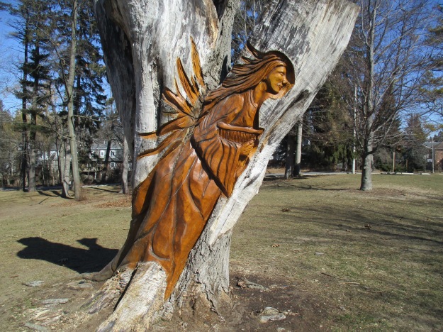
img_6705
We returned along the Imperial Oil Trail east toward the mouth of the Credit River.  Just east of the concrete drainage pipe from the oil lands is a lengthy finger pier extending out into Lake Ontario.  This pier provides great views to the west looking toward Rattray Marsh.  To the east, you can see the Ridgetown with the city of Toronto in the background. The ship is partially sunk at the mouth of the Credit River to provide shelter for the marina.  Our post on the Ridgetown contains its fascinating history.
img_6713
In the 1940’s Port Credit ended at Lake Street, of all places!  Today it extends out into the lake in the form of J. C. Saddington Park.  This park is built on a decommissioned dump that was in use from 1949 to 1970. A pond has been created for recreation and fishing and benches positioned around for relaxation. The pond has a thin layer of ice on it from the past two days of cold weather and a light dusting of snow.  A sliver of the moon can be seen above the trees in the middle of the picture.
img_6746
Three historic buildings stand in the corner of the parking lot. Dating from 1922 to 1923 the Port Credit Waterworks pumping station was a major advancement in the infrastructure of Port Credit.
img_6766
Swans, Canada Geese and several species of ducks were all to be seen in the lake today.  Of interest was the fact that they have gone back into pairs after spending the winter in groups.  Spring must be coming soon…
A 1973 Toronto Archive Aerial photo of the oil lands can be accessed here.

Mar 16, 2019

Mabel Davis Conservation Area (Newmarket)

This was one of those bone chilling days in late winter, just approaching spring, when we decided to check out another trail to walk off some calories after our AYCE lunches.  We decided to go to Mabel Davis Conservation area as the map showed us it was close.

You can enter the kilometre trail here either from Bayview Parkway or off of Davis Drive.  We started from the Davis drive location where we were able to find some parking off the side of the road.  

The trail is south of the Rogers Reservoir,  which I had blogged before (you can search for it to see some nice pictures of Holland landing).

This 7 hectare area is surrounded by city development, but you can still find a wide range of animals like rabbits, muskrats and raccoons.  Of course this time of year, the geese, ducks and drakes are in full swing totally acclimatized to the winters here in Canada.  

One of the most unique features of this trail however are the trail markers.  They are known as 'doodems' and they all use natural elements and are inspired by the Ojibwe ancestors.  There are 10 'doodems' in total.   I only captured 1 of them.  The OWL (GOOKOOKO'OO(G) - Which means wisdom and foresight.  Keeper of sacred knowledge.  This may largely be due to the fact that the owl is a great foreteller of weather conditions and are creatures of the night.


By the time we got as far as the Newmarket Radial Arch bridge, the sky had washed out creating a sombre feel (at least that's how I viewed it).  The Radial Arch bridge was built in  1909 by the Toronto and York Radial Railway company and is known to be one of the earliest reinforced concrete arches.  Standing on it's own now as a piece of history, it once supported part of a trestle bridge spanning the Holland river and Grand Trunk railway tracks. 
Newmarket is very proud of this parabolic arch which has a clear span of 15 metres and a rise of 7 metres.  The railway was discontinued in the 1930s, but since the arch was one of few of its kind, it was preserved in 1979 by the town of Newmarket.  I am not going to say I was impressed as today's standard architecture and engineering leaves this little archway paling...but considering the tools and technology we have today I will respect what I saw nonetheless. 

My final thoughts are this is a must see trail when the leaves are out and you might be able to catch some wildlife.  Also, I'd like to see all the 'doodems' when I have more time.

Oh, and who was Mabel Davis?  She was a lifetime resident of Newmarket who donated a strip of land to the Conservation Area.   She was the namesake for this trail.