Showing posts with label #bluffs. Show all posts

May 27, 2017

Scarborough Bluffs

I have often wondered if they had ever done a yearly analysis on the erosion rate of the Scarborough Bluffs, since I had noticed over time a substantial decrease in the height of the mountainous height of sand level. I did find this from a study in 1979. 
"Bluffer's Park, a 2.41km reach of Lake Ontario shoreline in the Borough of
Scarborough, was used as a case study.  The erosion rate, being an annual measure of a volume of material eroded from a linear metre of shore linehaving a bluff height of 1 metre (m3/m/m/yr), was found to be 0.34m3/m/m/yr.)  This rate is an average over the face of the bluff and is in the same range as the rates normally associated with other areas of Scarborough Bluffs. "


.
Springs first thaw has created flooding in certain parts of Toronto this year.  I've never seen the bluffers with so much overflow, leaving muck piles everywhere.  Water is rising due to global warming and I've heard the cottage is flooded, but we'll wait until we can get closer to check it out.

There are certain looks that the Bluff cliffs give that makes me think of Arizona for some reason? 

The layers of sand and clay exposed in these cliffs display a remarkable geological record of the last stages of the Great Ice Age. Unique in North America, they have attracted worldwide scientific interest. The first 46 metres of sediments contain fossil plants and animals that were deposited in a large river delta during the first advance of the Wisconsinan glacier some 70,000 years ago. They are covered by 61 metres of boulder clay and sand in alternating layers left by four subsequent advances and retreats of ice. The final withdrawal of the glacier occurred some 12,000 years ago.

They also found clay minerals int he triassic rocks in the colorado plateau, which would explain why I relate the two North American sites.


Aug 21, 2012

Scarborough Bluffs Park (Waterfront Trail)


Entering Bluffers from Brimley Road south
One of the first views while descending into Scarborough Bluffs Park (the "Bluffs") from Brimley Road, will be the awesome view of Lake Ontario as well as the colourful masts of the Yachts below lined row by row.  The Bluffs is an escarpment in Toronto, Ontario which forms most of the eastern portion of Waterfront Trail. At one point the escarpment is as high as 65 metres (215ft) and spans more than 14 kilometres (8.5 miles).  There are views from the escarpment that look as though you aren't in Toronto anymore, but rather some rugged coast land in England or Scotland.  I imagine this is where Elizabeth Simcoe (wife of John Graves Simcoe) was inspired to name the area 'Scarborough' after 'Scarborough, England'  when they settled in Toronto in 1793.  
View from east end of Bluffs

It's a geological wonder.   The escarpment formed the old shoreline of Glacial Lake Iroquois which appeared after the last ice age.  When you are up close to the escarpment you can see it looks like clay which has been baked and cracked.  In fact parts of the 'alluvial deposits" which are sediments that have been reshaped by the water,  had settled westward to form the Toronto Islands that exist now. 

Dunkers Flow Balancing System
Different areas of Bluffers Park
Was fortunate enough to catch a 'birds eye' view of a Blue Heron on the far northwest shore of Bluffers Park.  I believe this is where they nest.  Around the nesting area of the wildlife here there are long docks that are locked and gated off.  There is a purpose for this particular area because it is a stormwater treatment system that was specifically designed and invented by Karl Dunkers of Sweden.  The purpose is to reduce the harmful effects of polluted runoff that flows from the City's storm sewers before it enters Lake Ontario.  If you want to read up on the design it is called the "Dunker's Flow Balancing System" 

Alluvial deposits
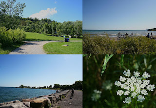
Bluffers Park  has a Restaurant, Yachting Clubs, Boat ramps, a Public beach and Picnic facilities and on any given pleasant day, you will most likely see gatherings of people, having picnics, sailing, or hiking through the many trails north of the lake closer to the bluffs, where there is an overgrowth of wildflowers and hidden coves.

Keep in mind though there are plenty of access points along the escarpment where there are no barriers, and erosion does occur along the edges and certain conditions like rain or snow can make the clay-like sandstone extremely slippery when wet.  Common sense takes precedence over curiosity here.  Especially since there are so many vantage points along the bluffs for great views without risking your life to do it :)